
Why Is This Hell's Kitchen Building Shorter Than It Was in 1966?
How the Special Clinton District preserved the stump of a rooming house it arrived too late to save.

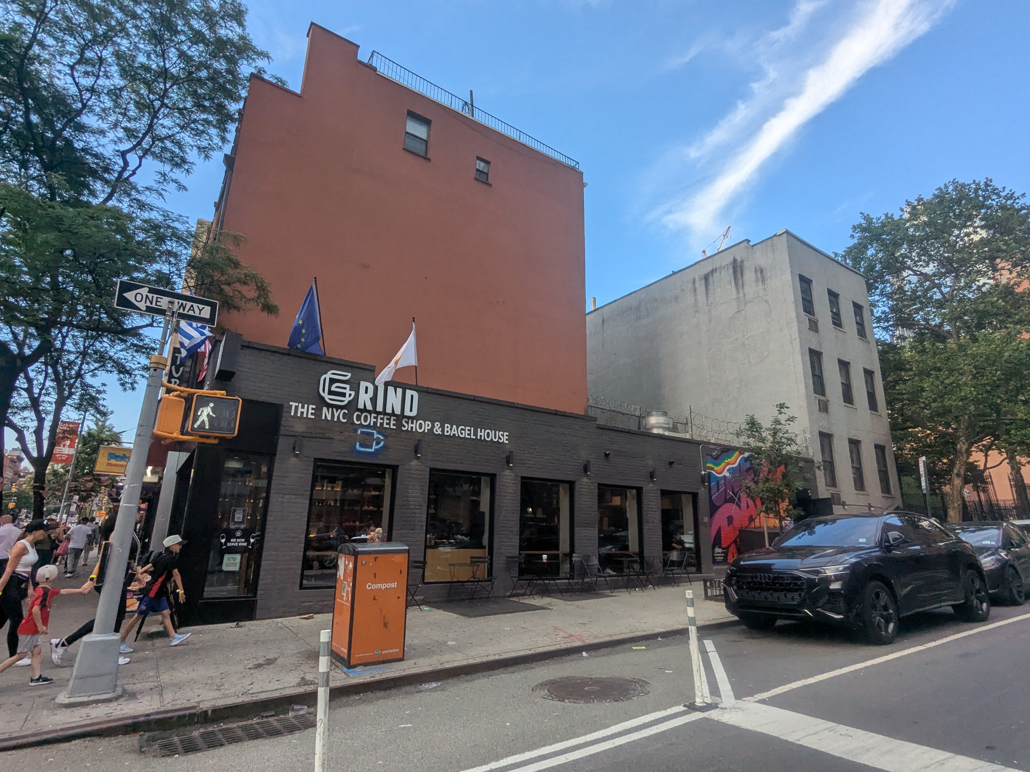
I can’t be the only one to wonder what’s the deal with this one-story coffee shop on a main commercial corridor in Hell’s Kitchen? After walking by it again earlier this summer, I decided to go dig into the records to figure out why this corner is used so unintensively. The story turned out to be about urban decline in the mid-20th century followed by a restrictive land-use regime that discouraged redevelopment right when demand for urban living came back.
The building is 602 Ninth Avenue, the northeast corner of West 43rd Street. Ten feet tall, 988 square feet, zero apartments. The certificate of occupancy allows 74 people to drink coffee inside.
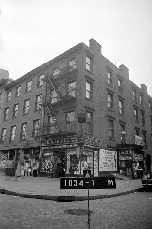
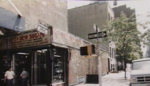
It used to look like the tax photo above. Four stories, fire escape, ground-floor menswear store (B.A. Prince, “outfitters of waiters, cooks,” full line of tuxedos, dressing the neighborhood’s service workers). The top three floors were rooming-house units and one conventional apartment. A Department of Buildings housing survey in August 1966 counted eleven Class B sleeping rooms on the third and fourth floors and one Class A apartment on the second, with a store on the ground. Class B and Class A are terms from New York State’s Multiple Dwelling Law: Class B means single-room occupancy, Class A means a conventional apartment.
Twenty-nine months later, the top three floors were gone.
“Remove pres. 3 stories”
I pulled the Department of Buildings folder for this lot from the archives downtown. The 1968 work was filed as an alteration, which let the owner keep the 1901 foundation, party walls, and floor joists without triggering the code compliance a new building would have required. The elevation drawings show a horizontal line running across the building at the top of the first floor. Above it, the three floors of windows are drawn in dashed lines, with an arrow and a three-word instruction: “REMOVE PRES. 3 STORIES.”
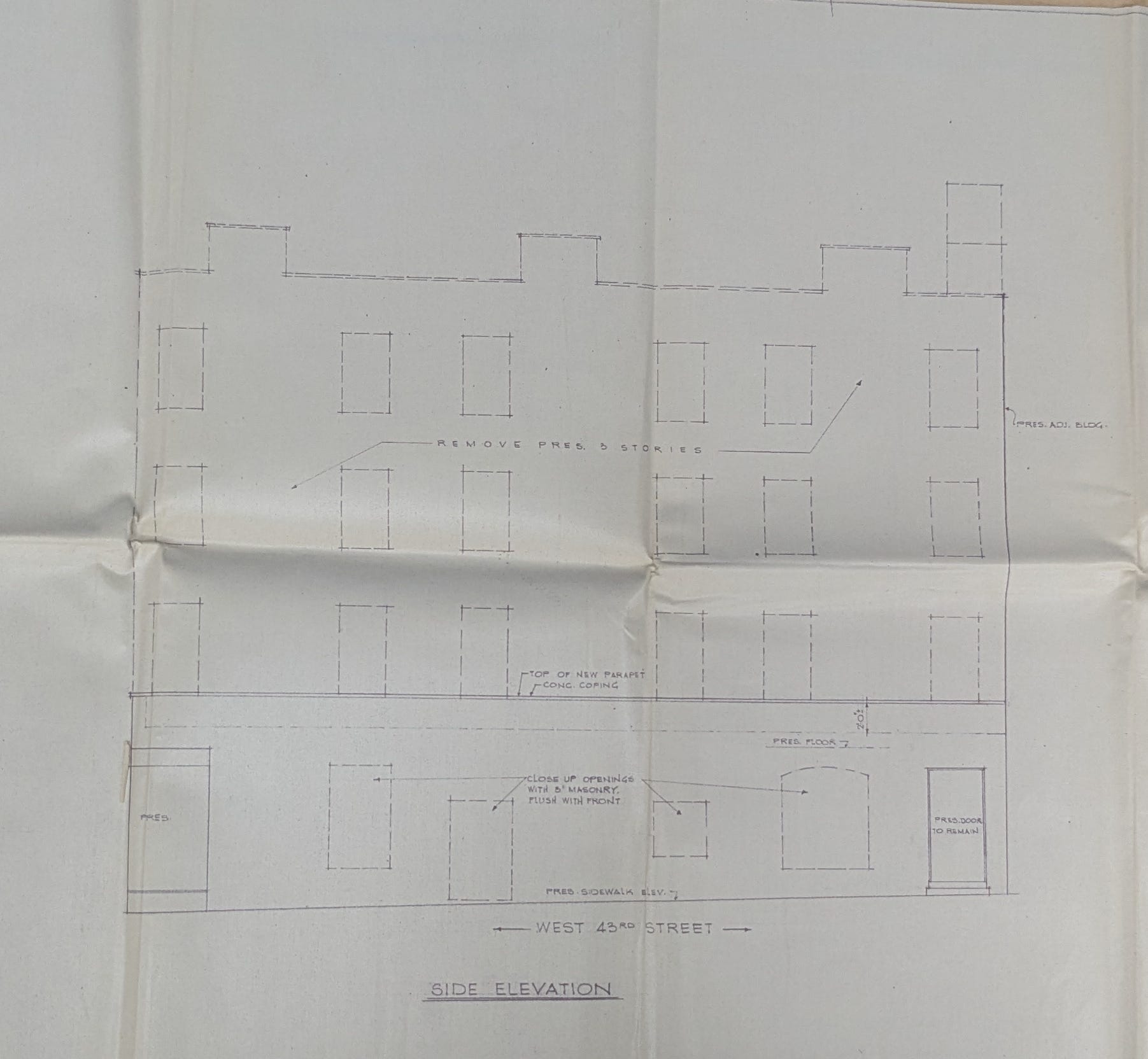
The demolition was surgical, because it had to be. The party walls stayed to hold up the four-story buildings next door, which leaned on them. The floor joists stayed to carry the ground floor. Window openings on the newly exposed walls were bricked shut. A two-foot parapet with a concrete coping capped what remained. The Department of Buildings signed off the finished product on January 15, 1969: one story, cellar storage, a ground-floor store, zero dwelling units.
Nothing in the folder suggests the demolition was forced. No fire, no collapse, no vacate order, no unsafe-building proceeding. Nothing in the file between the 1959 sprinkler upgrade and the 1968 demolition drawings shows any attempt to convert the rooming units to regular apartments either. The owner went straight from operating an SRO to knocking three-quarters of the building down.
Policy drew every version of this building
Every use this building ever held was shaped by regulation, and you can read the layers in the filings.
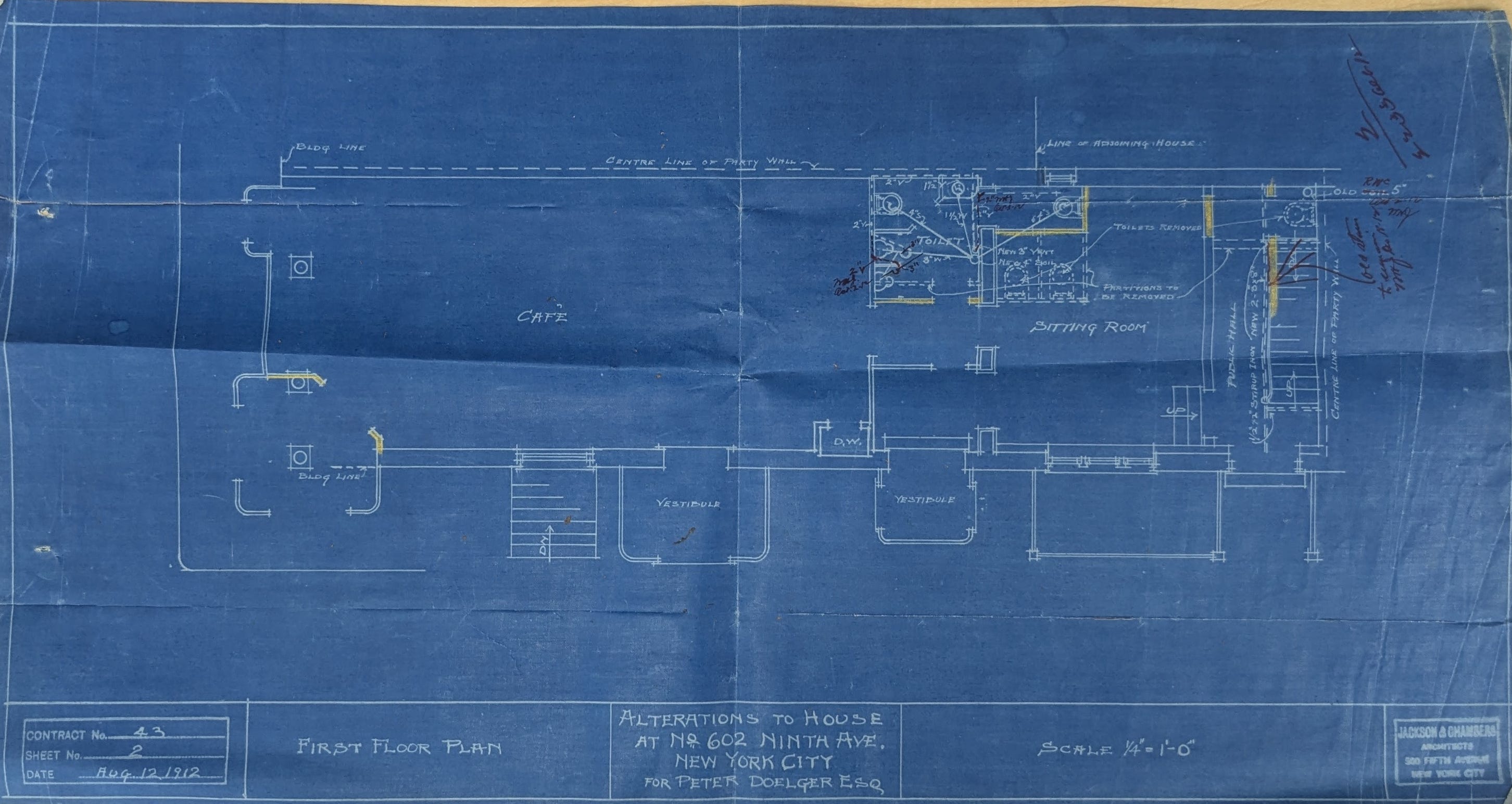
In August 1912 the brewer Peter Doelger, one of the largest in the city, filed alterations converting the ground floor. His architects labeled the room facing Ninth Avenue with one word: “CAFE.” The basement plan added an ice box, laundry trays, and new waste and vent lines. This was almost certainly a tied house, the pre-Prohibition business model in which “almost every restaurant, hotel and saloon in the United States” was part of a brewery-owned distribution network selling one brewer’s beer to the exclusion of all others. In this case a saloon selling Doelger to the dockworkers and Ninth Avenue El riders passing the corner. “Café” was the polite word architects put on drawings for saloons. Prohibition arrived seven years later and killed the legal version of the business.
In July 1937 someone paid to install a 22-head sprinkler system running through all four floors. That was money spent to keep upper-floor rooms legally rentable, not fun. The rooms were an asset worth protecting under housing law.
Then the incentives flipped. New York banned new SRO construction in 1955 out of a mid-century conviction that SROs were substandard housing that ought to be replaced. The same year the state launched J-51, the tax program that paid owners to convert single-room-occupancy units into market-rate apartments or commercial space. Federal urban renewal was condemning SRO buildings across Midtown. According to the Supportive Housing Network of New York, about 200,000 SRO units existed in New York City at midcentury; fewer than 40,000 remain today. The city government spent thirty years actively trying to eliminate the very housing type this building had provided.
The 1969 Plan for New York City said Midtown’s office district was going to push west into Clinton — the Plan expected the planned Convention Center on the Hudson and highway improvements would pull commercial development across Ninth Avenue. A four-story rooming house on a 997-square-foot corner lot was a tax liability sitting on appreciating dirt. The rational move was to cut it to a one-story “taxpayer”, a building whose entire job is to cover the property tax while the land waits for a boom.
Building code drew the saloon’s ice box. State housing law drew the sprinklers. City and federal SRO policy drew the empty upper floors. The property tax drew what was left.
Then the city preserved what was left
Five years after the top of this building went into a dumpster, the neighborhood got the protection that would have saved it.
The community had been asking for it. In 1973 the City Planning Commission adopted a one-year Special Clinton Interim Preservation District as a stopgap while consultants and community representatives drafted a permanent plan. The next year they were ready.
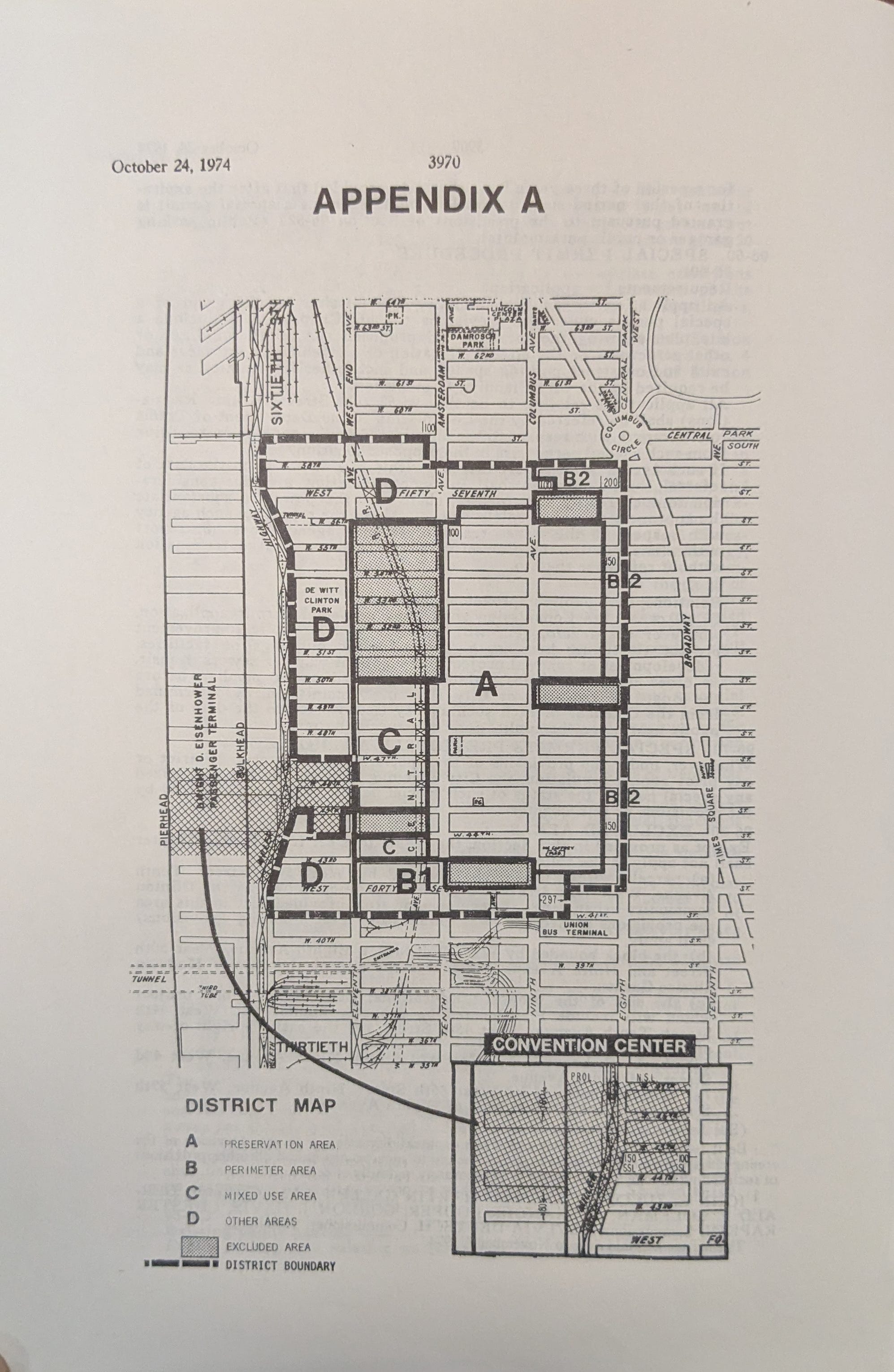
The City Planning Commission approved the Special Clinton District on October 21, 1974, six votes to zero with one abstention. The Board of Estimate adopted it unanimously on November 21, after laying the matter over twice. According to the Commission’s report, the district was written to protect Clinton from “the predictable development pressures caused by the construction of the Convention Center,” at the time planned for the Hudson River between West 45th and West 47th Streets. Pre-existing zoning, the Commission wrote, had “failed to protect the community from speculative development pressure.”
The Preservation Area was the core of it. Its boundaries, the Commission wrote, “are designed to include the heart of the Clinton neighborhood and the bulk of the area’s sound housing.” Inside it, demolishing a building that contained housing required a special permit from the Commission and the Board of Estimate, granted only if the tenants were properly relocated and the replacement building contained enough apartments to make up what came down. Side-street buildings were held to 66 feet or seven stories, whichever was more restrictive. New construction was capped at 4.2 FAR.
602 Ninth Avenue is inside the Preservation Area. It contained no housing to protect.
The district also went further than protecting what was standing. Section 96-105 of the adopted text set a floor of 48 square feet of lot area per room, required dwelling units to average at least three and a half rooms, and closed with one more sentence: “No new rooming units shall be permitted within the Preservation Area.” The plan written to save Clinton’s cheap rooms made it illegal to build any more of them.
And the same November 21 action downzoned the base. The Board of Estimate’s resolution lists C6-3 among the districts being converted and C6-2 among their replacements inside the new boundary. This corner sat in C6-3 in 1969, per the certificate of occupancy from that year. It has been C6-2 since. The corner got hit twice: the underlying zoning was cut, and the overlay was laid on top of the cut.
The parking lots won the only concession
Eighty-eight property owners filed verified protests against the rezoning. The Planning Commission calculated that they represented seven-tenths of one percent of the property inside the area, and that no owner of property adjacent to or across from the district had protested at all. Opponents “expressed concern that the Special District regulations could thwart development in some portions of the District,” the Commission’s report notes. On this corner, they were right.
The list of who showed up at the Board of Estimate to speak against it is a document in itself. The Real Estate Board of New York was there. So was Chrysler Realty, and Consolidated Edison. But the bulk of the opposition was the parking business: the Metropolitan Parking Lots Association, the Manhattan Parking Association twice over, the Metropolitan Garage Board of Trade, Square Parking, Square Plus Operating, Kinney System, M and W Parking, Katz Parking System, Mutual Parking Corporation. Teamsters Joint Council No. 6 and two IBT locals came with them.
They had a specific reason. The district banned accessory and public parking anywhere inside it without a special permit, and put existing lots on a clock. As the Commission wrote it, lots operating on November 15, 1973 could continue for three years and then had to stop.
That clause is the one thing the Board of Estimate changed before adopting the plan. The final text moved the start date to November 21, 1974 and stretched the grace period to five years, with an escape hatch if the city adopted comprehensive parking regulations for Manhattan in the meantime. The parking industry bought itself three more years and a reset clock.
Nobody amended the housing provisions. Speaking for them were Councilman-at-Large Henry Stern, Councilwoman Carol Greitzer, State Senator Manfred Ohrenstein, and Assemblyman Richard Gottfried, who would go on representing the neighborhood for another 48 years. Community Board 4, the Clinton Steering Committee, the McManus Democratic Association, and Project FIND came in support. Congresswoman Bella Abzug sent a representative on her behalf, missing the chance to make an appearance in her signature hat. So did the New York Convention Center Corporation, which was building the thing the district existed to defend against.
What eleven rooms would have been worth
The 1974 plan did not just restrict. It also priced Clinton’s old rooms, and the price was not nothing.
Section 96-211 offered a trade. Rehabilitate a room of housing inside the Preservation Area, hold the rent at $37 a month, keep it that way for at least five years, and a developer could add 500 square feet of floor area to a project in the Perimeter Area. The same October 21 action amended the Special Theatre District so that developers on a hundred-foot strip along the east side of Eighth Avenue, running from West 42nd Street up to West 56th, could increase their floor area ratio by 20 percent on the same terms.
So the deal on offer in 1974 was: fix up Clinton’s cheap rooms, build bigger on Eighth Avenue. Eleven rooms would have been worth 5,500 square feet on the avenue at the far end of this block. But fixing up the old, cheap housing at this site to secure additional zoning capacity nearby wasn’t an option because the horse had already left the barn.
Something like this machinery is still running. The Special Midtown District’s Theater Subdistrict overlaps the Clinton district along a 150-foot strip on the west side of Eighth Avenue between 42nd and 45th, and it lets designated Broadway theaters sell unused development rights to receiving sites; the Zoning Resolution sets a 6.02 FAR baseline for listed-theater lots inside Clinton’s C6-2 blocks, so theater density can move where ordinary density cannot. 602 Ninth Avenue is not a theater and has no rooms to rehabilitate. It sits on the same block as the receiving zone and can reach none of it.
It is worth being honest about what the “zoning capacity” on this corner really is. The 4.2 FAR cap technically leaves about 3,200 square feet of unused floor area on paper, and in theory that could move to a neighbor through a zoning lot merger. In practice the number is a fiction. A merger requires a neighbor planning something big enough to need the extra floor area, which means demolishing whatever is on the neighbor’s lot now, which triggers the same special permit gauntlet that discourages the project in the first place. The 3,200 square feet doesn’t move because nothing around it moves. That’s the point of the overlay.
None of the recent citywide housing pushes have touched this. City of Yes, the December 2024 amendment, rewrote the Clinton Preservation Area’s floor-area table but left the 4.2 base standing. What it added was the 5.04 figure, the citywide Universal Affordability Preference, a 20 percent bump available only for permanently affordable projects. On a 997-square-foot lot that is worth about 800 additional square feet. The Midtown South rezoning approved in August 2025, the largest residential rezoning in decades, stopped at West 40th Street.
The stump
The current owner has held the property since 1984. The mortgage was paid off in 1999, the parcel was moved into an LLC in 2019 and into a revocable trust in 2025. Forty-one years of a single family with no sign of moving. The Department of Finance values the property at $1,029,000 and has carried the land value at exactly $350,000 every year since at least 2015. That’s about $350 per square foot of dirt, three blocks from the Times Square subway. The Department of Finance’s own building classification for this parcel is K1: “Store Buildings (Taxpayers Included), One Story Retail Building.” It is literally called a taxpayer in the city’s records.
Among the general purposes the Commission wrote into the district in 1974 was this one: “To promote the most desirable use of land in the area and thus to conserve the value of land and buildings, and thereby protect the City’s tax revenues.”
The Special Clinton District does what it was designed to do on the blocks where the housing still exists. In late 2025, Community Board 4 caught an improperly filed demolition at 404 West 50th Street and forced the Buildings Department to reject it. There are tenements and their tenants elsewhere in the Preservation Area whose continued existence you can credit to this overlay. When the housing is standing, the overlay defends it.
This corner is different. Here the housing was already gone before the district was drawn, and for the fifty-two years since, the overlay hasn’t been able to do anything except administer the loss. It can’t distinguish between a building worth preserving and the stump of one. It preserves the stump.
In 1966 this corner rented eleven rooms and an apartment above a store. In 2026 it pours coffee. The corner doesn’t need protection. It needs to be built.
Anyone know other Manhattan corners like this?
Looking for one-story taxpayers or otherwise conspicuously short buildings on commercial avenues where the lot clearly used to hold something bigger. Bonus if you know roughly when it came down.